Previously, I played around with SVG and JavaScript in order to create interactive maps of Central American primates.
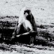
As a followup, I thought I’d try my hand at mapping baboons, given that they are the critters I am currently working with. Baboons inhabit lots of countries, so I included a bonus feature. Clicking on the map will help identify some of those more obscure countries. Try it out!
As with before, the original PDF project file is available for download under a Creative Commons license.
Distribution of baboons (genus Papio)
| ? | ? | ? |
| ? | ? | ? |
Click map to identify countries
Use the menu above to display species. Click on the map to identify countries/territories.

This work is licensed under a Creative Commons Attribution 3.0 Unported License.
 RSS
RSS
I look forward to stealing this for use in presentations. Cool stuff, Kenny!
Pingback: Baboon Distribution Map | Monkeyologist